
Where can I go hiking?
Flagstaff is a hiker’s paradise. There are trails in town and out of town and pretty much all around town. There is bound to be a trail to suit your needs.
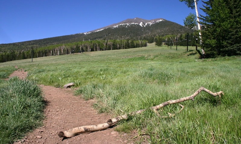
Deer Hill Trail #88
This short, easy trail has views of the San Francisco Peaks and if you’re quiet you might see some wildlife like mule deer or elk. Also, don’t forget your camera—this trail is open during the summer and fall and is perfect for capturing the changing of seasons.
- Distance: 5 miles
- Average Time of Hiking: 3 hours
- Elevation: 7,180 to 7,280 feet
- Elevation gain: 100 feet
- Difficulty: Easy
- Trail Type: Hiking/Biking trail
- Trailhead: Park next to Little Elden Spring and walk to the horse camp; the trail starts there.
Campbell Mesa Trail
This trail system is a fairly flat area just outside of Flagstaff and is made up of five different hiking loops, all of which are connected and can be reached at the same trailhead. This system is great for people who want to wonder amongst the Ponderosa Pine trees.
- Distance: 11.3 miles
- Average Time of Hiking: 3-4 hours; varies on how many different hiking loops you take.
- Elevation: 6,723 to 6,880 feet
- Elevation gain: 157 feet
- Difficulty: Moderate
- Trail Type: Hiking trail
- Trailhead: Just off of Country Club Road turn left onto Oakmount and drive for a half mile until you see the sign for Campbell Mesa Recreation Access.
Sunset Trail #23
Beginning near Schutlz Tank, one of the few bodies of water in the mountains, this summer trail provides views of the San Francisco Peaks, Sunset Crater and the Painted Desert. Sunset trail also connects with several other hiking trails such as the Elden Lookout Trails, which is perfect for photographers.
- Distance: 4 miles
- Average Time of Hiking: 2.5 hours RT
- Elevation: 8,000 feet to 9,275 feet
- Elevation gain: 1,275 feet
- Difficulty: Moderate
- Trail Type: Hiking trail
- Trailhead: It is located on Forest Road 420 at the parking lot on the south side of the road.
Water line Trail
This trail will take you along the Inner Basin, Abineau Canyon, past Sunset Crater and the Painted Desert. You’ll get stellar views of all the major sites plus some wildlife if you’re lucky.
- Distance: 14 miles
- Average Time of Hiking: 12 hours RT
- Elevation: 8,000 -10,400 feet
- Elevation gain: 2,400 feet
- Difficulty: Moderate
- Trail Type: Hiking trail
- Trailhead: The trailhead is at the parking lot near Forest Road 146.
I am looking for a hiking guide
There are several gear stores and guides in town for you to utilize before your hike. See the listings on this page.
